
 When El Niño develops in the Pacific, it shifts the jet streams, triggers extreme droughts and flooding, and puts marine ecosystems under stress. Here’s everything you need to know.
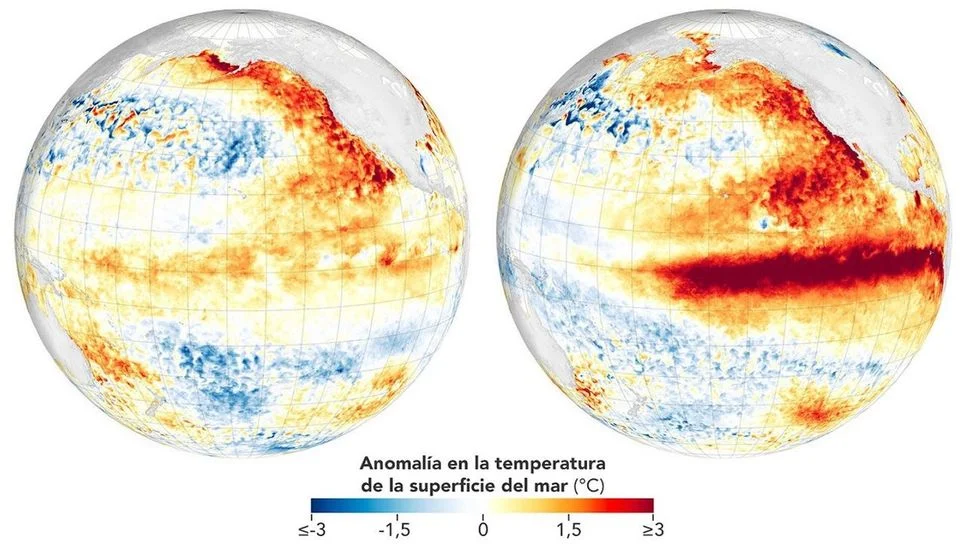
El Niño is associated with above-average equatorial sea surface temperatures. Source: NASA Earth Observatory (MUR SST).The ocean contains a complex underwater system that helps regulate the planet’s thermostat. Deep below the surface, currents and water masses converge and transport heat and nutrients for thousands of miles. When the temperature of these layers changes, it can trigger a chain reaction that transforms weather patterns around the world.
The equatorial Pacific acts as Earth’s primary heat reservoir because it receives intense solar radiation. Under normal conditions, the trade winds push warm water toward Asia and Oceania, concentrating heat in the western Pacific while maintaining a steady flow of nutrients along the coasts of the Americas.
This dynamic is part of a pattern known in atmospheric science as the El Niño-Southern Oscillation (ENSO). This ocean-atmosphere system shifts between neutral conditions, a cool phase known as La Niña, and a warm phase commonly known as El Niño.
The warm phase begins when the trade winds weaken or reverse direction. Without that push, the enormous mass of warm water flows eastward, extending as deep as 200 meters before reaching the coasts of the Americas, altering the ocean’s thermal structure along the way.
How El Niño affects the atmosphere
This ocean warming directly alters global atmospheric circulation. Massive evaporation from unusually warm waters releases enormous amounts of energy, shifting the path of the
Original Record.
This archived record authored by ‘Dainet Sierra’ at ‘METEORED (Your Weather)’ was recovered from data set:
 English